Top Bike Paths in Boston and the Suburbs
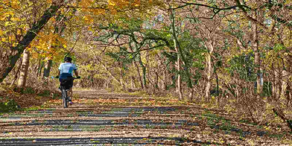
Boston’s bike scene shines in every season, but fall brings extra color to the region’s rail trails and riverside paths. These eight routes balance convenience, scenery, and rideability, with MBTA access and suburban reach for anyone planning a two‑wheeled outing.
At-a-Glance
- Start points: Boston, Cambridge, Somerville, Newton, Concord
- Time: 1–4 hours
- Distance: 3–20 miles
- Surfaces: Paved or stone dust
- Bathrooms/water: Available at most trailheads and parks
- MBTA/parking: Red, Orange, Green lines; commuter rail options
- Dogs/strollers: Allowed on multi-use paths
- Season: Year-round, best foliage Sept–Nov
Charles River Bike Path
The Charles River Bike Path is Boston’s signature ride, stretching about 17 miles from the Museum of Science to Norumbega Park in Newton. It offers flat, paved miles alongside the water, with skyline views and leafy stretches perfect for fall foliage. Popular with commuters and casual riders alike, it connects seamlessly with city parks. Expect some crowding on weekends, but the views are worth it.
- Distance: ~17 miles
- Surfaces/elevation: Paved, flat with some road crossings
- Bathrooms/water: Public restrooms at Esplanade, BU Bridge, Herter Park
- MBTA/parking: Red and Green lines at multiple entry points
- Dogs/strollers: Multi-use friendly
- Season/cautions: Year-round; fall brings heavy leaf‑peeping traffic
- Link: mass.gov/charles-river-bike-path
- Last checked: Aug 25, 2025
Southwest Corridor Park
Running four miles from Back Bay to Forest Hills, the Southwest Corridor Park is a green commuter artery through the South End and Jamaica Plain. The paved path passes playgrounds, basketball courts, and gardens, making it lively but not overwhelming. It’s a reliable ride for anyone seeking color without leaving the city. Evenings bring heavier bike traffic, but mornings are calm.
- Distance: 4–5 miles
- Surfaces/elevation: Paved, flat
- Bathrooms/water: Available at Ruggles and Forest Hills
- MBTA/parking: Orange Line along route
- Dogs/strollers: Multi-use, family friendly
- Season/cautions: Best in fall for tree color; watch for commuter cyclists
- Link: boston.gov/southwest-corridor-park
- Last checked: Aug 25, 2025
Minuteman Bikeway
Tracing Paul Revere’s historic ride, the Minuteman Bikeway runs from Alewife Station through Arlington and Lexington to Bedford. Over 10 miles of paved rail trail, it’s shaded and wide, with plenty of trailheads and signage. In fall, the leafy canopy adds a vibrant backdrop. Popular with both leisure riders and distance cyclists, it’s one of the region’s most beloved paths.
- Distance: 10.1 miles
- Surfaces/elevation: Paved, gentle grades
- Bathrooms/water: Arlington Center and Lexington Depot
- MBTA/parking: Red Line Alewife; parking in Arlington and Bedford
- Dogs/strollers: Allowed
- Season/cautions: Year-round; peak fall weekends are busy
- Link: minutemanbikeway.org
- Last checked: Aug 25, 2025
Arnold Arboretum Loop
Within Boston’s Arnold Arboretum, this 4.5-mile loop mixes gentle climbs with vibrant fall foliage. Paved roads wind past historic plantings and sweeping views of Boston from Peters Hill. Cyclists share space with walkers, but wide roads and slow traffic keep it relaxed. It’s best enjoyed as a leisurely ride paired with leaf peeping.
- Distance: 4.5 miles
- Surfaces/elevation: Paved, rolling hills
- Bathrooms/water: Visitor Center at Arborway entrance
- MBTA/parking: Orange Line Forest Hills; street parking nearby
- Dogs/strollers: Dogs on leash; stroller-friendly
- Season/cautions: Gorgeous in fall; some paths close in icy weather
- Link: arboretum.harvard.edu
- Last checked: Aug 25, 2025
Deer Island Trail
Deer Island offers a 4.6-mile paved perimeter loop with harbor views and historic markers. The ride mixes breezy shoreline with rolling terrain, plus access to picnic areas and restrooms. It’s a tranquil alternative to city rides, especially in fall when the air is crisp and crowds are thinner. A ferry ride adds adventure for those starting downtown.
- Distance: 4.6 miles
- Surfaces/elevation: Paved, rolling
- Bathrooms/water: Facilities near trailhead
- MBTA/parking: Ferry from Long Wharf; parking on site
- Dogs/strollers: Allowed
- Season/cautions: Best fall views; windy in winter
- Link: mwra.com/deer-island
- Last checked: Aug 25, 2025
Somerville Community Path
The Somerville Community Path extends 3.2 miles through Davis Square and toward East Cambridge. Recently expanded, it links smoothly with the Green Line Extension and Red Line at Alewife. The path is paved and lined with murals, trees, and neighborhood energy. In fall, the blend of foliage and city makes it one of the best short rides.

- Distance: 3.2 miles
- Surfaces/elevation: Paved, flat
- Bathrooms/water: Limited along route; Davis Square nearby
- MBTA/parking: Red Line Alewife, Green Line Lechmere
- Dogs/strollers: Allowed
- Season/cautions: Year-round; short but highly used
- Link: somervillema.gov/communitypath
- Last checked: Aug 25, 2025
Bruce Freeman Rail Trail
Stretching over 20 miles from Lowell through Acton and Concord, the Bruce Freeman Rail Trail is one of the longest suburban rides near Boston. Wide and well-maintained, it passes wetlands, woodlands, and neighborhoods, all lit up in fall color. Cyclists love it for long-distance, low‑stress riding. Future expansions will add even more mileage.
- Distance: 20 miles (current open section)
- Surfaces/elevation: Paved, flat to rolling
- Bathrooms/water: Town centers along route
- MBTA/parking: Commuter rail Concord/Acton; trailhead parking
- Dogs/strollers: Allowed
- Season/cautions: Stunning foliage in fall; open year-round
- Link: brucefreemanrailtrail.org
- Last checked: Aug 25, 2025
Mass Central Rail Trail (Wayside)
The Mass Central Rail Trail’s Wayside section links Weston, Wayland, and Waltham. Still expanding, it features a mix of paved and stone‑dust surfaces through woods and wetlands. It’s less busy than Minuteman, offering a quieter suburban alternative. Fall highlights include colorful foliage and peaceful wetland views.

- Distance: 10+ miles (varies by open sections)
- Surfaces/elevation: Paved and stone dust
- Bathrooms/water: Trailheads in Weston and Wayland
- MBTA/parking: Commuter rail to Waltham; parking at trailheads
- Dogs/strollers: Allowed
- Season/cautions: Best in fall for foliage; incomplete connections
- Link: masscentralrailtrail.org
- Last checked: Aug 25, 2025